

Severe weather systems moving through South Carolina have prompted the National Weather Service (NWS) to issue multiple severe thunderstorm alerts for several counties across the state, highlighting the ongoing risk of damaging winds, hail, lightning, and heavy rainfall that can impact daily life and safety. These alerts are part of broader storm activity affecting the Carolinas region, where varying levels of severe weather risk have been identified due to atmospheric instability and storm‑producing conditions.
What the Severe Thunderstorm Alerts Mean
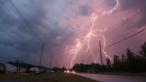
A severe thunderstorm alert is declared when weather conditions are favorable for or are already producing intense thunderstorms capable of generating wind gusts exceeding 58 miles per hour, hail at least one inch in diameter, dangerous lightning, and intense rainfall. These storms can develop rapidly and pose significant threats to both life and property if precautions are not taken.
While some of the most recent watches and warnings included counties in the Lowcountry region — such as Charleston, Berkeley, Dorchester, and adjoining areas — the threat has also extended toward inland regions where atmospheric conditions favor storm development.
Areas Recently Under Alerts
Officials have identified several South Carolina counties under severe thunderstorm watches and warnings as storm systems moved into the region, including parts of the Lowcountry and central portions of the state. Counties like Charleston, Berkeley, Dorchester, Colleton, Beaufort, Williamsburg, and Georgetown were under watches or warnings during peak storm activity, where conditions remained favorable for thunderstorms capable of producing damaging winds, lightning, hail, and heavy rainfall.
These alerts often come ahead of strong storm fronts propelled by temperature contrasts and atmospheric instability, especially during warmer months when heat and humidity fuel storm development. Meteorologists noted that damaging wind gusts (often in excess of 60 mph), hail, and frequent lightning were among the primary concerns, with isolated tornadoes also possible under certain conditions.
Timing and Duration of Alerts
Severe thunderstorm watches and warnings typically specify a time window during which storm activity is most likely or underway. For example, officials reported that the severe thunderstorm watch in the Lowcountry was expected to remain in place into the late evening as storms tracked through the region, driven by a strong cold front moving across the state.
During these periods, residents are advised to remain vigilant and monitor local weather information via official NWS updates, mobile alert systems, and credible media outlets. Alert durations can change rapidly if storms weaken, track away from populated areas, or intensify, prompting escalations to warnings.
Key Weather Hazards and Risks
Severe thunderstorms can produce a variety of hazardous conditions. Damaging winds can uproot trees and down power lines, resulting in outages and debris on roadways. Large hail can damage vehicles, roofs, and outdoor equipment, while frequent lightning increases the risk of fires and injuries to anyone outdoors.
Heavy rain associated with these storms can lead to flash flooding, rapidly overwhelming drainage systems in urban and rural areas alike. Although flooding wasn’t always the primary focus of every alert, particularly strong or slow‑moving thunderstorms can quickly drop significant rainfall amounts in a short period.
How Residents Can Stay Safe
Effective preparation and awareness are crucial during severe weather alerts. Residents in affected counties should:
-
Monitor alerts through NOAA Weather Radio, trusted weather apps, and local news sources.
-
Seek shelter indoors, especially away from windows, when severe thunderstorm warnings are active.
-
Secure outdoor objects that could be blown around by strong winds.
-
Avoid travel if possible during peak storm activity, as debris and flooded roads pose dangers.
These steps help reduce exposure to hazards and ensure personal safety throughout severe weather events.
Local emergency management agencies also recommend having a family emergency plan and ensuring that phones and weather radios are charged to receive timely notifications.
Broader Weather Pattern and Forecast
The issuance of multiple severe thunderstorm watches and warnings reflects broader atmospheric patterns affecting the southeastern United States, particularly during the storm season when heat and humidity combine with frontal systems to spark intense weather.
Across the Carolinas overall, meteorologists have identified enhanced risks for severe weather in certain periods, as storms develop ahead of cold fronts or heat‑driven instability moves through the region. These dynamics can elevate the likelihood of numerous severe thunderstorms in a single day, emphasizing the need for ongoing weather awareness.
Final Thoughts
Multiple severe thunderstorm alerts in South Carolina counties serve as a reminder of the importance of weather preparedness, especially during active storm periods when conditions can change quickly.
By understanding the nature of these alerts, the specific risks involved, and the steps needed to stay safe, residents can better protect themselves, their families, and their property whenever severe weather threatens. Stay informed through official National Weather Service updates and local emergency communications as conditions evolve throughout the storm season.